30 Sept 2013

Day 9 (29-Sep-13) Moab - Page (283 miles)

After the previous night’s excesses, bodies and minds were very fragile when the ‘Gang of 5’ assembled for breakfast at 08:30hrs. In contrast to the barely contained excitement and engaging conversation of just 24hrs earlier, breakfast today was a decidedly muted affair. Simon, in addition to suffering various self-induced and transmitted physical ailments (and possibly one or two congenital psychological ones too), also found himself owning a sick computer, as the hard disk had completely crashed. I personally would have succumbed to a fit of epileptic rage had that occurred to me. Simon, however, to his great credit, exhibited ‘True Grit’, accepting the gravity of the situation with great aplomb and a level of stoicism not seen since Major-General Gordon was heard to say ‘Oh Dear’, just before he was beheaded, following the complete annihilation of his forces at Khartoum by local rebels, in 1885. 

Following decidedly muted recollections of our trip to Canyonlands and discussions of plans ahead, we went our separate ways to attend to personal errands. We then convened one final time for tearful farewells in the car park at the La Quinta, with Dave & Kerri flying back to Houston, while ‘Q&A’ plus ‘Third Wheel’, continued on to Page, Arizona.

The journey to Page was uneventful, but as with every car journey to date on this holiday, very scenic. The transect of Monument Valley park through Navajo lands was particularly spectacular – we half expected to see John Wayne emerge from behind one of the many buttes. Again, the clear sunny skies and verdant plains (the result of recent severe storms that spanned Arizona, Utah and Colorado) perfectly offset the many freestanding ochre red buttes and massifs dotted across the park. Other than a few stops for obligatory snaps of the pristine and almost extra-terrestrial landscape (many ‘photo-bombed’ by Simon), we made our way, slowly - very, very slowly – to Page, with ‘Aunty’ (Simon’s schizophrenic half-blind doppelganger of ‘Mother’) at the wheel.
 
Once in Page we immediately made for Antelope Canyon Tours to try and get Simon a place on our particular tour of this famous slot canyon, scheduled for the following day. Alas, they we temporarily closed for a ‘pow wow’ among staff. We thus headed to our hotel instead, and after numerous phone calls, managed to get Simon a place with another group. With no escape routes from this very deep and narrow canyon, and even a pin drop reverberating with deafening cacophony off the canyon walls, I fear for the sanity of those entering the canyon with Simon tomorrow - lambs to the slaughter on a scale that demotes Passchendaele to a brief military skirmish by comparison.

With the imminent demise of so many weighing heavily on our minds, we elected to do a little exploring around the Glen Dam, which took 10 years to complete, and opened in 1966. Situated on the Colorado river, Lake Powell quickly formed behind this massive structure, with the city of Page growing around the dam during its construction. The views of the lake and the canyons around its edge are truly stunning.

29 Sept 2013

Day 8 (28-Sep-13) Canyonlands NP (88 miles)

We awoke to clear blue skies, with temperatures for the day not expected to exceed 70F. The air was also crystal clear, with an occasional slight breeze masking an otherwise fierce sun (as attested by our very sun-burnt faces). After yet another leisurely start and equally enjoyable fibre-and-fruit-filled breakfast, we embarked on a day trip to Canyonlands NP, driving along the ‘Island In The Sky’ mesa. Even at the park entrance, the views down into Shaefer Canyon literally took our breath away. Following some scrambling for obligatory ‘shots of the day’, which involved navigating over some precariously exposed boulders, we continued into the park.  

A view of our next stop is available to anyone with a computer running Windows 7 – it is included in the default library of desktop backdrops.  Mesa Arch is perched on the edge of the cliff face that drops down from the mesa to the White Rim plateau +/- 1500ft below. Simon, always on the lookout for a suitable setting for his next lifesize self-portrait painting, fearlessly scrambled onto the roof of the arch and proceeded to complete 10 push-ups under the gaze of stunned, dumbfounded, bemused, amazed and a not a few annoyed tourists. After grudgingly relinquishing his ‘throne’, the assembled masses were able to capture photos of the view through the arch to the massive canyon system far below – Gooseberry Canyon, Buck Canyon and Lathrop Canyon.

Suitably impressed, we continued south along the mesa, stopping off at Candlestick Tower Overlook, Buck Canyon Overlook and Orange Cliffs Overlook, before arriving at Grand View Point Overlook. The views from here defy description, easily exceeding my not inconsiderable lexicon of superlatives. To the east is the Colorado river and the west the Green river, with the confluence of both easily visible due south at 12 miles. Further south still are The Needles, a long buttress extending east from the confluence, featuring sharp castellations. The vistas extended in all directions to the far-off horizon, which given our elevation, was +/-50 miles distant, with the snow-covered tops of mountains to the south-east visible over 80 miles distant.

The ideal weather conditions, high perch, and with the sun past its Zenith, made for ideal photography. Our only problem was trying to figure out how to capture the vast landscape on camera. Astrid’s solution was to divide the 180-degree panorama into sectors, and then photograph each in exquisite detail, using her ‘weapon of choice’. She will then ‘stitch’ the various photos together at a later date – I can’t wait to see the final result. Suitably impressed, we then embarked on a 1-mile hike westward along the edge of the mesa for better views back of the massive buttes rising from the Soda Springs Basin to the east. After retracing our steps, we continued eastward for better views of the Colorado river system.
 
On returning to the car, we headed back north along the mesa and forked left at Mesa Arch for a hike up the Whale Rock. This afforded us fantastic views of Candlestick Tower, a butte which rises over 2000ft from the Soda Springs basin. We could also see other sections of the Green River. Duly impressed, we headed back to the park entrance, intending on retracing our steps back to Moab. However, on the way back, we elected to take a quick detour to visit Dead Horse Point state park. This 10 mile detour provided much better views of the Colorado river, which meanders in large bows towards Moab, and ultimately discharges into Lake Powell.

Now completely drained we limped back into Moab to revive body and mind, using means to access parts unreachable with traditional medicines, or alternative homeopathic remedies - alcohol. So immediate was this impact that we elected to immediately follow-up with dinner – and more alcohol!

28 Sept 2013

Day 7 (27-Sep-31) Arches NP (41 miles)


Following leisurely breakfast at 08:00hrs, Simon elected to spend the day entertaining himself – more on that escapade from himself later. The Morgans & Nowowiejskis instead spent a leisurely day back in Arches NP to visit some of the many other landmarks, in particular the famous Delicate Arch. Getting there however involves a strenuous 1 mile hike up the side of a large sandstone massif.  We thus decided to prepare our bodies first with a hike to the more accessible Windows, via a scramble to the Double Arch and Cove of Caves.

Following obligatory numerous photo stops, water stops and even greater number of toilet stops (none of us seemingly have particularly strong bladders) we drove to Wolfe Ranch; the starting point for the hike to the Delicate Arch. There, we first visited the small wooden cabin that was home to the Wolfe family at the turn of the last century. They ran a small cattle farm in this beautiful yet unforgiving place. The hard physical work required to survive in this arid terrain, and the tiny cabin that was home to two adults and four children, comes as a great shock to many park visitors. Emboldened by the hardiness of these settlers, we embarked on our hike up to the Delicate Arch (though for some reason David preferred to refer it as the Tender Arch). After much panting and weasing, we eventually reached our destination, with the NPS clearly intent on ensuring that only those willing to go the full distance be rewarded with spectacular views of the arch and its vertiginous surroundings.
 
After a few minutes spent taking photos of the arch, from various angles, Kerri decided she’d had enough and so retreated to the safety of a flat hollow. The rest of us followed after absorbing the fabulous vistas stretching in all directions to distant horizons. We then slowly descended back to the car, where we had ‘lunch’ (trail mix, beef jerky and a few energy bars).  Suitably rested and refreshed, we then drove slowly to the Devil’s Garden Trailhead for 0.5 mile hike to the Landscape Arch. This equally famous landmark, spanning 290.1ft, is the longest natural arch in the world, and almost appears to defy gravity. With Astrid and Kerri electing to stay behind to capture photos of this natural wonder, Dave & I scrambled up one of the rock fins to visit nearby Navajo Arch and Partition Arch, with the later affording spectacular views of the snow-covered mountains behind Moab. We then decided to explore the surrounding canyon to find a vantage point from which we could look back down onto Landscape Arch. After some false trails our efforts were duly, and suddenly, rewarded. The views of the arch, and Fiery Furnace labyrinth behind, were literally dizzying.
 
We hastily retreated from our perch to be back with our women, after which we made our way slowly out of the park, stopping now and then for photos of the late afternoon sun, casting big shadows over the many buttes, hoodoos, arches and pinnacles. On the way back to town we also stopped to view some ancient Petroglyphs, which sadly had been partially vandalised in 1980 – with many expletives uttered at this desecration. After a few beers at a local ‘spit-n-sawdust' joint, we showered and then feasted and wined at a fabulous Italian restaurant.
 
Captain Sweatpants Log - Supplemental
 
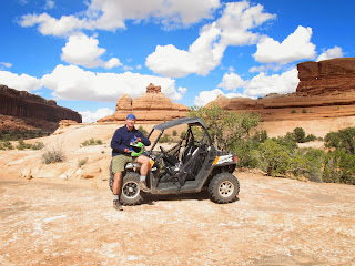
The arrival of crew re-enforcements from star base Houston enabled me to rent a shuttle RZR ATV vehicle, beam down alone to the planet's surface. The thought of this great solitude in this huge expanse of wilderness, after days of umpiring the Morgan marriage, made my spirits soar! I looked forward to exploring the veritable moonscape that lay outside of carefully manicured Arches National Park, particularly at speeds of up to 40 km ( heart rate 65 this time) on clearly marked tracks.
 
Despite specific map instructions not to attempt Seven Mile Rim! I found myself inexorably drawn to the challenge of the precipitous climbs, impassable ridges and long sandy up & downhills sections. As is often the case, I came to regret the moment when my over confidence met my inexperience and inability to manifest itself in pure terror!!
 
It had all begun so well when I headed at high speed to Uranium Arch and then more circumspectly over rocks & boulders along the ridge to Monitor Butte & Merrimac Butte, massive individual structures on a rocky outcrop. Of course that is where the trouble started....... Traversing this outcrop required climbing vertical walls above Wipeout Pass (they are not known for exaggerating with their descriptions in Utah), clinging to impossible ridges and over the pass before hurtling down into what days earlier had been a raging riverbed (Wadi) after the flash floods. There really were moments where I thought we were going to roll down the precipitous, smooth rock faces and came to understand why they had such re-in forced roll cages in these vehicles.......Well, me and RZR survived and sped off to Determination Towers (how very apt!!) at maximum warp speed to catch the now forming cotton wool cloud formations gathering around clearly distinguishable micro weather systems over the mountains.

To complete a fabulous 50km loop, I stopped at Tusher Tunnels and walked through the system to emerge into another valley in bright sunshine with stunning views. A massive downhill run back to base camp to meet the 5 o'clock deadline, transfer into the Murano and then a Deep Tissue Aromatherapy Massage by a lady who appeared to have a map of the entire Moab region tattooed across her body. Her powerful hands and deep kneading caused trauma to most of my internal organs with occasionally her thumb prints protruding through my chest.

A fabulous day, in wonderful solitude, destroyed only by the prospect of a full house Italian dinner and a scientific update from Quentin Attenborough....... 
 

Day 6 (26-Sep-13) Capitol Reef NP - Arches NP (212 miles)

Having finally been allowed to escape the parallel universe created by Captain Sweatpants and Sheldon, I feel it is my duty to give a more accurate and factual account of today’s proceedings. I apologise for the lack of embellishment, exaggeration, twisting of facts and outright lies, used by my fellow travellers to draw you in to their world of fantasy - and my world of hurt. This may of course, make for less entertaining reading, however, it should provide you with a more balanced report of our trip.

Wake up call was at 06:00 hrs. As I have the pleasure of sharing a room with someone suffering a mild case of the flu, my roommate (also known as husband) nonetheless insisted on attempting to expel copious amounts of phlegm overnight, ensuring neither of us could have a decent nights’ sleep. An excellent start to the day!

Prior to commencing our drive down/up to Moab, we stopped off at a little European style cafĂ© for a quick breakfast and obligatory wakeup cupper. As no points of major interest were to be encountered en route it was deemed most prudent to have a reliable, yet speedy, driver take control of today’s journey to Moab. I decided that should be me, rather than Captain Sweatpants (a.k.a. “Mother” when behind the wheel) or Sheldon (who really should never be behind any wheel of any vehicle).

Today we were scheduled to meet up with Dave and Kerri Nowowiejski, who were kind enough to make the trek across country from Houston to spend some time with us. Unfortunately, the planned Fiery Furnace tour would start prior to their arrival, which meant we would not be able to have our long overdue reunion until later that evening. This also meant trying to keep Simon safe from himself, and others from him, whilst attempting to enjoy a guided tour through the infamous labyrinth of the Fiery Furnace. A similar area in this region was made famous by Aaron Rolston, who had to cut off his forearm when struck by catastrophe.

To ensure we would reach the designated meeting point on time, we decided to “slowly” make our way through the park and already take in some of the scenic vistas we encountered en route. With Quentin also having visited this park on a previous occasion, we were treated to warnings such as “you’ll really like this one”, “I’m looking forward to the look on your face when you see the next one” and comments such as the obligatory “shot of the day!”. Thus enlightened, we reached our meeting point in good time, barely allowing us a quick restroom stop.

As the members of the group slowly gathered, it became clear that the term “arduous” used to describe the trek surely could not be correct. We found ourselves mixing with people made up of old, young, tall, short, fit and the not so fit. Simon immediately managed to bully some members of our group into conversation and we, as ever, felt obliged to provide a warning as to the risks involved in reciprocating with any hint of politeness - which is seen as weakness by the Interlocutor Troll. However, for some reason, our warnings continue to fall on deaf ears,  possibly because our interjections come too late, with victim's hearing already irreperably damaged. Indeed, some people even seemed happy to talk to Simon. However, it is not until you get to see the blank, startled-deer, look in their eyes that you realise all is not well, and that a means of escape should be provided.

Our tour guide for the day, Ranger Amanda provided a brief description of what was to be expected, and once everyone was aware those taking part would be responsible for themselves, and any children they brought with them, we descended into the canyon. Although constant attention was required to ensure a safe descent, the trek proved to be quite easy, with frequent stops along to the way to provide Ranger Amanda the opportunity to educate us on canyon history, and its flaura and fauna. Three hours after setting off we emerged with all members of the group present and accounted for, and each making a hasty retreat to the safety of their vehicles, out of earshot from Simon. The only person we’d been able to spare the harangue of the Interlocutor Troll was our guide, but that was only after convincing Simon she was vital to our survival, and should therefore not be distracted by, or engaged in, conversation.

As the sun was not its usual self during the afternoon, we were spared the sweltering temperatures that normally prevail in these canyons during this time of year. Therefore, although we felt we should reward ourselves with a post-exercise drink, our retreat from the park was marked by more stops at various scenic points. Once back in Moab we checked in to our hotel, and after reaching Dave and Kerri, made arrangements for the evenings’ entertainment. Simon discovered that Moab would be hosting a “Gay Pride” party at the weekend, so was eager to sample what the town has to offer on special occasions such as this. He therefore decided he should meet in our “local”. I shall not go in to the details of the state Simon was in when we eventually met him in said local. Suffice to say he has now added the addresses of various biker dudes to his Black Book.

We finally met Dave and Kerri on the way to the restaurant, and following warm felt hugs all around, and introductions to (and some quietly whispered warnings about) Simon, we dived in to our old habit of eating and merry drinking.

27 Sept 2013

Day 5 (25-Sep-13) Bryce Canyon NP - Capitol Reef NP (176 miles)

Captain's Blog - star date?? The Trekkie Big Bang US Road Trip continues...
 
Having managed to temporarily incapacitate the alien being known to many as Q, to others as his latest incarnation, Sheldon, Mork, or Spock (half human), or to me as Data (fully Android), we have temporarily managed to gain control of the blog records. Using my recently acquired Suunto Ambit 2 sports watch, featuring 8 sensors (the real 'hebbe dingje' which Q modified one evening into a Star Trekkie Tri-corder) I have only been able to detect 2 human life forms in the vehicle, Astrid (Penny, or is it Mindy) and I.  

Q (first science officer) has been producing copious amounts of a green mucous material, coughing & spluttering his way through our adventures "to boldly cough where few men have coughed before."  Simultaneously, he has been disgorging voluminous tomes of geological and scientific data and facts on the lunar type landscapes which we find ourselves in, whilst giving a detailed history of the creation of our solar system, including Earth, and also climate change. His internal hard drive however has apparently gone into an infinite loop sequence, that sees him take thousands of photos and then proclaim after each "shot of the day." This is usually followed by "glorious cover drive." Strangely there are never any people in Data's photos, something he calls visual pollution of great scenery......A reboot is clearly long overdue and I have administered the medication to do it. 

So back to today. We managed to sleep in until 07:00hrs, had coffee at the European style cafe 'Little L's', (which thankfully had US style prices), and then set a course with the Garmin GPS navigator to Capital Reef National Park, on the very edge of the heliosphere. Our first trek after the Visitors Centre briefing was up the Grand Wash gorge and into the canyon which time had clearly forgotten. Just days earlier the region was hit by flash floods, where 50% of the annual precipitation fell in 2 days, washing away many of the trails and roads in the area. Danger is our middle name.

Unperturbed, we ventured forth, coming across many petrified giant iguana's which littered our path, as we manoeuvred along the canyon floor. We half expected to see Raquel Welch in a loin cloth running towards us at any moment, chased by pre-historic creatures.........or perhaps by bands of marauding Australian misogynists. Sadly, this did not occur!!! This deep foreboding canyon was boxed in on both sides by steep walls of variegated sandstone and volcanic ash.

It tells the story of extraordinary geological change over hundreds of millions of years, caused by upthrusts of biblical proportions, cataclysmic events that saw ocean floors become mountains, mass extinctions (5 so far, with one, The Great Dying, eradicating 90% of all species), asteroid strikes, supervolcano eruptions, and most devastating of all, by Homo sapiens, who came to the area only 10,000 years ago.

Some 3 hours later we emerged battered and a little bruised and then set off for Capital Gorge, with its iconic Cassidy Arch and Golden Throne structures. The way my stomach was feeling the Golden Throne was a great destination!! On this occasion, we needed to travel fast and light, so I only took Data with me to chronicle my trip, most particularly the gym session on the very Arch itself which included 50 press ups at 7,000ft. Sadly, I had not counted on Data's alien physiology, where on the ascent my Suunto Tri-corder was registering my heart rate at 155 bpm, whilst his heart rate barely broke 100. We ran down the 1000 ft descent to re-join 'Penny', who was entertaining the locals with tales of derring-do and looking for a man named Aaron Andrews from Calgary.......

The photos attest to the amazing scenery and freaks of nature that we encountered along the way. As the sun began to set, huge winds blew up across the plains and we were forced to retreat to a Ribs And Steak house, affording glorious views of the Red Rock ranges, viewed through 3 bottles of Pinot Grigio, several Corona's and very large food portions. Q, as is his want, proceeded to consume his entire body weight in food, burped loudly and then retired to his quarters, taking Penny along with him. I stared into darkness with intrepedation, worrying what the morrow would bring once the ephedrine that I had added to Data's drink actually took effect.

Could I survive the full 14 days of the Trekkie Big Bang road trip, or would my head explode with all the knowledge that I was being drip fed in our Vulcan mind meld sessions??

26 Sept 2013

Day 4 (24-Sep-13) Zion NP - Bryce Canyon NP (192 miles)

Following ritual rude awakening at 06:00hrs we would have been on the road at 07:00hrs, but for usual 15 minute wait for Simon to complete ablutions, facial deep-pore cleansing routine and timeout for introspective self-admiration.  Armed with a Lemsip and drugs to keep my head cold at bay, we headed back to Zion NP and immediately diverted onto Zion Park Boulevard. After passing through the mile-long tunnel that provides access to the upper plateau we parked the car and hiked the Overlook Trial for more breathtaking views of Zion NP. Along the way we also spotted more Big Horn Sheep. 
 

We then continued to Bryce Canyon NP, stopping numerous times en route to take photos of the dramatic limestone and sandstone monoliths dominating the upper plateau. Once at Bryce we immediately headed for the Scenic Rim trial, which affords spectacular views of Bryce Canyon, a place where superlatives abound and other worldly terrain becomes the norm. Following a walk to Sunrise Point we then descended into the canyon, emerging at Sunset Point. We then headed back to the car, stopping first for quick snack at the Lodge, then drove on to Inspiration Point and Bryce Point for more spectacular views of the pinnacles in the canyon. 
 
Having visited this canyon 3 years ago, almost to the day, I was not sure if I would experience the same sense of awe and amazement at seeing this natural wonder. However, this time I was able to share the experience with my soul mate and a very close friend also. The weather on this visit was also much better suited, with sunny blue skies contrasting the ochre red sandstone dominating the base of the canyon. Simon, ebullient as ever, managed to superimpose himself on the vast majority of photographs, inventing a whole new catalogue of poses, some of them leading passers-by to question his sanity - and manhood.
 
We then continued by car to other vantage points along the ridge, ending at Yovimba Point. Along the way we encountered a small group of Pronghorn, the fastest land animal in the world over 1km. These antelope were completely unperturbed by our presence, no doubt due in part by the fact that hunting is prohibited inside park boundaries. At 9100ft Yovimba Point affords spectacular views across the shattered terrain, stretching all the way to the Grand Canyon, over 100 miles distant.  And to witness this vast landscape, with no one else present, and nothing but evening song from the many bird species present to break the silence, and the sun setting behind us, was a very, very, special moment.
 
Having duly imbibed Nature in all Her glory, we then headed for the park exit, stopping off at Ruby’s Inn for a sumptuous feast, washed down with copious wine and beer. What a wonderful day! And what better way to share it with others! What a special place!


25 Sept 2013

Day 3 (23-Sep-13) Zion National Park (46 miles)

 
We were again up at 06:00 and found ourselves driving at break-neck speed back up to Zion NP by 07:00hrs. Once there we got on the bus for ride to The Grotto, the starting point for the famous hike up to Angel’s Landing – also listed in the Top 10 hikes by National Geographic. The hike is steep and so not for the faint of heart. It is also very vertiginous, with massive drop-offs either side of the very narrow saddle leading up to the summit. It is thus not suited for those who suffer from vertigo either. We set off at 08:20hrs, with air temperature decidedly chilly. However, after 10-15 minutes of strenuous exercise, our bodies soon warmed up.
 
At one point during the ascent I became alarmed by a loud yet squeaky noise. Suspecting that we were being chased by a giant hamster, I turned, and immediately realised the source of this ungodly sound was Simon’s rapid shallow breathing.  Clearly agitated, Simon protested that this condition was ‘normal’, and proceeded to show the display on his Suunto Ambit2 as evidence. However, on checking his profile settings, it transpired he had selected ‘Lessor Loris’ as user; a deceit as outrageous as Simon’s entries into his food diary.
 

On reaching the col Astrid decided to stay behind, while Simon and I pushed onto the summit. The route along this last section was indeed very tricky, and demanded total concentration, as one false slip could spell disaster. However, the prize was worth every pensive step, with the summit affording spectacular panoramic views of the Zion canyon and the giant rocky sentinels either side. Simon then proceeded to shatter the tranquillity of the moment by approaching every other visitor to this haloed spot with an abridged version of his life story. In fear of being either stoned to death, or thrown off the summit by the assembled masses, I beat a hasty retreat back to Astrid. Simon followed close behind, ensuring everyone else still making their way up the narrow ledge was likewise lectured.

After descending back to the Grotto we immediately caught the bus for the short ride to the Temple of Sinawava. We then walked the 1 mile to the entry point into the Virgin River for the famed hike up to The Narrows. This involved wading upstream for 2.5 miles, in cold water, against a fairly strong current, and over a series of small rapids. However, despite these challenging conditions, our efforts were amply rewarded with views of the canyon walls, rising steeply several thousand feet on both river banks, slowly encroaching on each other. In places, the darkness was almost total, with no means of telling the time of day, despite the bright mid-afternoon sunny conditions high above. At The Narrows itself, the walls were just a few feet apart, leaving those that had managed to venture this far into the slot canyon wondering if this might be the entrance to Middle Earth.
 
After retracing our steps back to Terra Firma we caught the bus again for the ride back to the park entrance, arriving back at the car at 17:10hrs. After 9 hours of almost constant hard physical exercise, and having had just an apple for lunch, we were all famished. We thus gorged ourselves at a local Mexican restaurant, washed down with a few beers.

Day 2 (22-Sep-13) Death Valley - Zion NP (405 miles)

We departed our cottage in Panamint Springs at sunrise and headed back to Stovepipe Wells Village, where we picked up breakfast at the local general store. We then drove on to the entrance of Titus Canyon,  at which point we hit the dirt track that meanders down through this very remote region of Death Valley NP. The route through the canyon is narrow, steep, and in places, very exposed, with very sudden drop offs. Astrid however was up to the task, steering the AWD vehicle with consummate skill. The scenery en route was spectacular, with the pastel hues of the exposed stratigraphy spanning the entire visible spectrum.

On exiting the canyon we embarked on the long drive to Zion NP. The route passes through four states – California, Nevada, Arizona and Utah. The long straight roads, hot climate and bright sun made for tiring driving conditions. We were, however, very sensible, with all three of us taking turns at the wheel.  We also stopped on the outskirts of Las Vegas to refuel the car, body and mind. The landscape on the final leg through Arizona and Utah gradually changed from flat desert to high mountains, providing us a foretaste of the very dramatic scapes in Zion NP.

After dropping off our gear at the Hotel in the town of Huricane, we continued on Zion for an evening hike to the start of The Narrows, a stretch of the Virgin River at the head of the canyon that is listed as one of the top ten hikes in USA by National Geographic. On the bus ride back to the park entrance we also watched the sunset over the peaks that rise almost vertically for nearly 4000ft on either side of the canyon.

Day 1 (21-Sep-13) Los Angeles - Death Valley (423 miles)

Awoke 06:15hrs, excited at the prospect of meeting my wife, Astrid, who was in the final approaches to Los Angeles from Brisbane. Clearly, Simon, who had shared the hotel room with me for the night, was still suffering the effects of jet leg. He was equally excited and also clearly intent on perpetuating a practice he had honed with consummate skill on Kokoda, leaving bits of essential luggage strewn across the entire route, arriving at the finish in nothing more than undersized speedos. And so we left the hotel with Simon’s rain jacket still in the wardrobe!

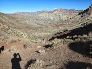
Astrid duly exited Tom Bradley airport close to schedule, but only after being exhorted for overstaying her visit visa in 1994 by 4 days and threatened with immediate expulsion – it would seem The Morgans are deemed ‘undesirables’. However, with formalities behind us, we picked up our 6-cylinder AWD SUV and headed out of Los Angeles under cloudy skies along famed 10-lane concrete highways. Once we had crested the pass on the Antelope Valley Freeway, the clouds gave way to clear blue skies, as well as gusting winds, which stayed with us for the rest of the day. We were greeted with our first view of Death Valley at Father Crowley Vista Point by noon, with temperature at this elevation already a ‘toasty’ 90F. It was evident even from this remote vantage point that the valley floor was being blasted by high winds, with huge dust plumes sweeping all asunder. We then descended the Inyo Mountains to Panamint Springs, close to sea level, for brief pit stop.

At 14:15hrs we then continued over the Panamint Range (a 4200ft ascent/descent) to Stovepipe Wells Village, where we picked up our $80 multi-entry park pass, which is valid for a year and allows access to all US national parks. We then hugged the eastern side of Death Valley to Furnace Creek, at which point we began the long climb to Dante’s View, situated on top of the Amargosa Mountains at 5475ft. Along the way we stopped at Zabriskie Point for views of ancient volcanic ash deposits that have been moulded by flash floods into great folded sheets. The vista from Dante’s View of the valley below, which is below sea level , were truly stunning. Despite the ferocious winds, we edged our way along the ridge to capture views of the entire valley floor, which stretches over 70 miles N-S. We then descended to the lower point on the valley floor at Badwater. At 282ft below sea level this area is also the lowest point in the Americas. Even at 18:15hrs the temperature was brutal (over 100F). After obligatory photo shoot we slowly meandered our way back to Panamint Springs, arriving both hungry and thirsty at 20:15hrs.